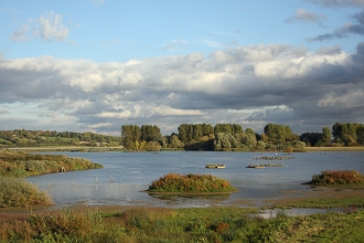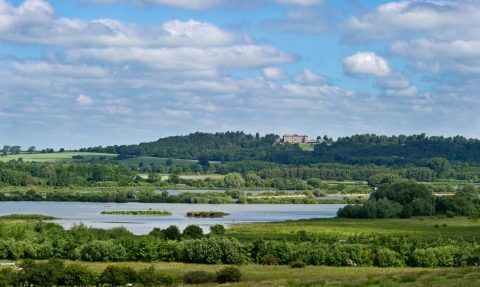
View of Rutland Water nature reserve in early summer - David Tipling/2020VISION
About Rutland Water
Rutland Water Nature Reserve
It's hard to imagine that less than fifty years ago, if you'd stood in the village of Hambleton, you would have been surrounded by fields. In the 1970s, the scene would change entirely and the Hambleton Peninsular would jut out into what was to be the largest man-made lake in the UK. The reservoir was innovative and visionary right from the planning stage. It would bring together people, wildlife and business, including the creation of a 500 (now 1,000!) acre nature reserve at the western end. It is now an internationally recognised Site of Special Scientific interest (SSSI), Special Protection Area (SPA) and a Ramsar Wetland of International Importance.
Thank you for being one of the most fantastic wildlife spots in the country. It was the best wildlife experience we’ve ever had.8TTPhotography
Rutland Water
Originally named Empingham Reservoir after a local village, Rutland Water lies near Oakham. It was completed in 1976 and covers 3,100 acres. At its maximum, it is thirty-four metres deep and 1,200 metres long. The 1,000 acre nature reserve lies at the western end, and Rutland Water is famed for it's wildlife: in fact, the nature reserve was designated before the reservoir had even been built!
Wildlife
Rutland Water Nature Reserve, and the wider reservoir, is an outstanding haven for wildlife in the heart of England. A network of lagoons and wetlands, including the western tips of both the north and south arms of the reservoir, provide a sanctuary for water birds, birds of prey, woodland wildlife and more. Several reintroduction programmes have proactively restored otherwise rare wildlife, with both ospreys and water voles being introduced to the area.
The reservoir provides one of the most important wildfowl sanctuaries in Great Britain, regularly holding in excess of 25,000 ducks, geese and swans in the winter. it is heavily protected by law, being a Site of Special Scientific Interest, a European Special Protection Area and internationally recognised as a globally important wetland RAMSAR site.
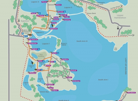
The nature reserve covers the shoreline and shallow water lagoons along 9 miles of the western end of Rutland Water and covers a total area of 1000 acres. There are over 30 bird watching hides and nature trails from two visitor centres. It is also home to the Rutland Ospreys which in 2001 celebrated the first Osprey chick to fledge in Central England for 150 years.
A mixture of water levels, habitats and management strategies have led to Rutland Water providing a haven to literally thousands of birds comprising hundreds of species. Check out our guides to spring, summer, autumn and winter to discover what species you're likely to see at different times of year.
Conservation
Rutland Water Nature Reserve is carefully managed to ensure that conditions stay just right for wildlife, taking into account the rising and falling water levels of the reservoir, and other factors like climate change. Each lagoon provides different conditions for different species, and the meadows and woodlands are looked after, too, ensuring that species like nightingales can always make a home here.
The secret to success has been the relationship between Leicestershire and Rutland Wildlife Trust and Anglian Water. A project to enhance the habitats, completed in 2011, extended the nature reserve by 240 acres (to cover a total area of 1000 acres), creating nine lagoons made up of shallow water, islands and scrapes. Some of the lagoons are much deeper, and we've also added additional features like tern rafts, a swift tower and artificial reefs below the water, all supporting different plants and animals. We also make the most of grazing, using Hebridean Sheep and Dexter Cattle to help crop down our grass and churn up some of the muddy water edges.
History
Rutland Water is the perfect coming together of people, wildlife and business, showing how all three can thrive together. The reservoir, one of the largest manmade bodies of water in Western Europe, covers over 4 square miles, and the path around the edge is 23 miles long! To build the reservoir, it was necessary to flood some of the small local villages, including Nether Hambleton and Middle Hambleton, which were cleared of people. The reservoir, when full, has enough water for about three years of drought, supplying much of the East Midlands.
The creation of the reservoir involved damming the Gwash valley near Empingham, and was completed in 1976. Flooding took a further three years. During its construction, it was known as Empingham Reservoir. It flooded six or seven square kilometres of the Gwash valley as well as the side valley at the head of which lies Oakham.
The clay dam is 115 feet high, and around 1,200 metres long. The finished structure has been landscaped to blend in with the environment, even when viewed from Empingham, the nearest village.
As well as watching wildlife and walking, there are a number of other activities to take part in around the edge of Rutland Water, including bike hire, water sports and fishing. There are several other visitor centres offering a range of family activities and events for all ages and abilities, making Rutland Water a major recreational hub for the East Midlands.
Matthew Roberts
Plan your visit
