
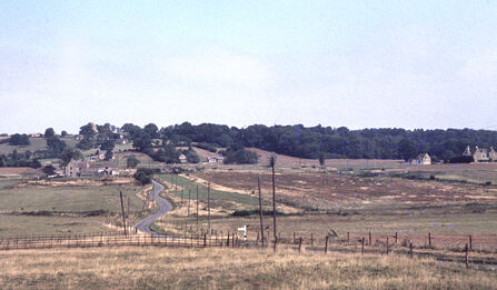
Looking towards Normanton Bridge from the Hambleton Road, near Half Moon Spinney, in 1971, when most of the trees had been removed from this part of the valley.
Credit - Richard Adams
The History of Rutland Water and its Nature Reserve
50 Years of Rutland Water Nature Reserve
In 1963, the Welland and Nene River Authority and the Mid-Northamptonshire Water board reviewed the future water demand for their areas of operation. With the post-war boom of the 1960s, population growth in the Northamptonshire area was predicted to be well above national average. The construction of a new reservoir was proposed to meet demand and keep taps running.
Over 60 valleys were considered. Many were too small or too remote, or were geologically unsuitable for construction. Only two sites would be left, the Chater and Gwash valleys within the heart of Rutland.

An aerial photograph of the River Gwash and Normanton Fishpond at high water level circa 1969. Normanton Church can be seen at the bottom left.
Credit - Squadron Leader Fred Adams
The valley must have a suitable shape, so that the reservoir will hold plenty of water, the ground must be strong enough to bear the weight of the dam, and the dam of course mustn’t leak so the geology must be right. There must be plenty of local material from which to build the dam, there must be a river reasonably near so that a large quantity of water can be obtained to fill the reservoir, and lastly of course, the site must be sufficiently near the centre of population where the water is wanted, so that the pumping costs are not too high.Welland and Nene River Authority engineer
Although a reservoir was planned for each of the valleys, what was initially called the ‘Empingham Pumped Water Storage Project’, would be built first thanks to its larger capacity and lower operational costs. The Chater valley plan would later be shelved.
In May 1970, Parliamentary approval was given and work commenced in June of the same year. It would not be until 1979, after the flooding of 3,000 acres of countryside, £30 million spent, and the droughts of 1975 and ‘76, that the reservoir would be filled to its capacity under the new name ‘Rutland Water’.

An aerial view of Rutland Water, looking east.
Credit - Rutland Local History & Record Society
It should be the aim of each of us to leave our chosen corner not more vulgar and submerged, but lovelier and more dignified, after we have gone.landscape architect appointed to ensure the reservoir looked like a lake upon its completion.
Construction
The construction of Rutland Water was a huge civil engineering project. A dam had to be built, buildings levelled, lengths of pipeline lain and tunnel systems excavated. Though the reservoir would be partially supplied with water from the dammed river Gwash, water from the rivers Welland and Nene would supply the bulk of the water needed, requiring the construction of new pumping stations and supply systems.
Many spinneys and woods would have to be fully or partially removed and the river Gwash diverted for construction to begin. Several hundred Oak and Birch trees were moved from Hambleton Wood and replanted above the planned water line. Upper Lias clay was excavated and used to construct the dam; a stipulation of the project that building materials had to be sourced from within the reservoir’s area. New roads were constructed to replace those that would be lost due to the flooding. Manpower, alongside machines and drills, played a large role in the construction of the reservoir’s tunnels. Tunnel gangs placed 83kg segments of concrete by hand in cramped conditions. In one ten-hour shift, 51 lining rings, each made of 12 segments each were placed.
After years of work, the dam was ready and the pumps at Empingham, Tinwell and Wansford were first switched on in September 1975. Though the reservoir was completed in 1976, significant water accumulation did not begin until 1977, owing to the droughts of the previous two years. In March 1979, Rutland Water was finally filled to capacity for the first time.
Community Impact
With 3% of the county due to be flooded under the reservoir’s area, the local community, villages and landscape would be forever changed. Rutland Community Ventures have conducted a series of interviews with people who were affected by or involved with the construction of the reservoir: Don t Drown Our County on Vimeo

The location of Upper, Middle and Nether Hambleton on J & C Walker's map of 1878.
Survey Work and the Rutland Natural History Society
Ecological surveys are an incredibly important part of the conservation work that is undertaken at Rutland Water and its nature reserve. The records from this work stretch back to even before the reservoir was filled thanks to the efforts of the Rutland Natural History Society. Started by a group of enthusiasts in 1965, the Society recognised that once the reservoir was filled, any information on what species had been present in the Gwash Valley would be lost. Over five years they covered as much ground of the valley as they could in the time available, surveying mammals, birds, insects and plants.

RNHS survey party standing on a footbridge over the River Gwash south-west of Brake Spinney, looking upstream. From left to right, Betty Eaton, Joan Levisohn and Dr Erica Hutton.
Credit - Jim Levisohn ARPS
Ruddle’s Puddle
Several names were considered for the new reservoir. ‘Ruddle’s Puddle’ was perhaps a tongue in cheek suggestion in reference to Sir Kenneth Ruddle, who at the time campaigned against local government reorganisation. Rutland had lost its independence in 1974 and had become a district of Leicestershire (it was re-established in 1997). ‘Empingham Reservoir’ was the presumed choice but after a spirited local campaign and then petition submitted by Jane Merritt, a Rutland Sixth Form College student, ‘Rutland Water’ was proposed and accepted in 1976 – a way to perpetuate the county name, perhaps a sentiment that can be recognised today.
Normanton Church
A possible casualty of the reservoir’s construction was Normanton Church. Thanks to Anglian Water and the hastily-assembled Normanton Tower Trust, a plan for saving it was put together. Floors were raised, lower levels filled, and a causeway and embankment built around it to ensure it would not be flooded. Thanks to this fast action, the church was able to reopen as a museum and nowadays is visitable as a functions venue.

The Gwash valley looking north from Normanton in 1974.
Credit - Richard Adams
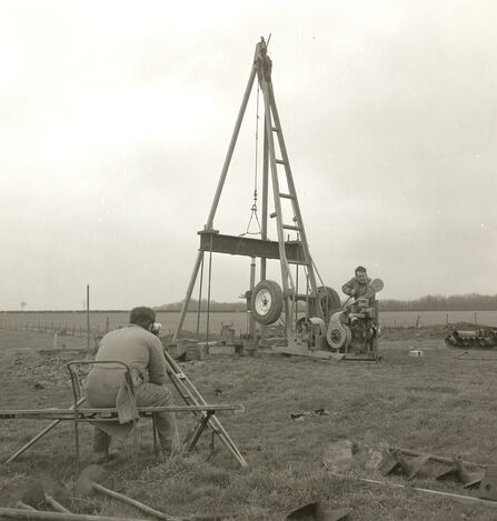
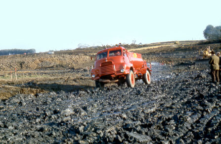
Drilling one of the many boreholes in order to establish the exact geology of the valleys.
Credit - Brian and Elizabeth Nicholls Photography
Building of the dam for Rutland Water in 1973.
Credit - Richard Adams
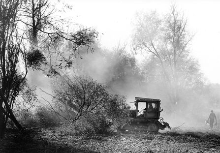
Vegetation clearance near Armley Wood.
Credit - Rutland Natural History Society
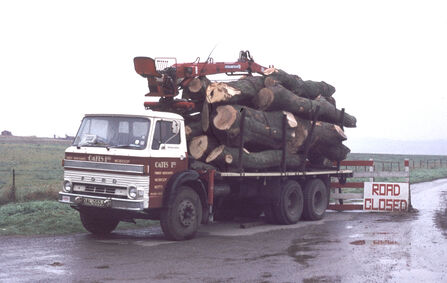
One of the many lorry-loads of timber felled during the reservoir clearance programme.
Credit - Richard Adams
The landscape cleared of hedges and trees near Nether Hambleton.
Credit - Richard Adams
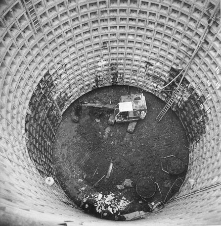
Excavating the reservoir outlet shaft.
Credit - Brian and Elizabeth Nicholls Photography
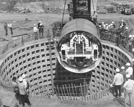
Lowering the tunnelling machine into the outlet shaft.
Credit - Brian and Elizabeth Nicholls Photography
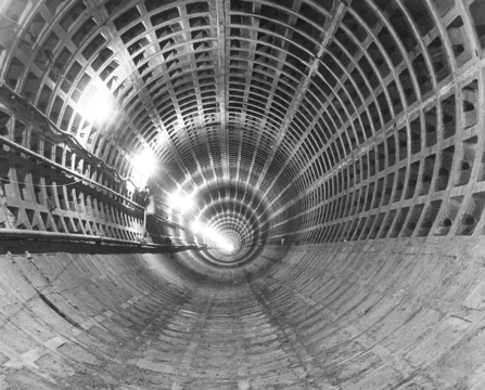
The downstream diversion tunnel.
Credit - Brian and Elizabeth Nicholls Photography
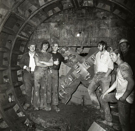
Miners at the Empingham end of the Tinwell to Empingham tunnel celebrating a successful breakthrough.
Credit - Brian and Elizabeth Nicholls Photography
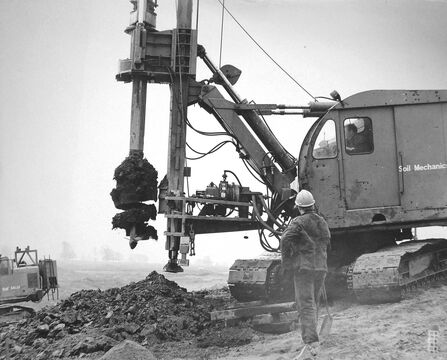
A crawler crane-mounted auger drilling a sand drain.
Credit - Brian and Elizabeth Nicholls Photography
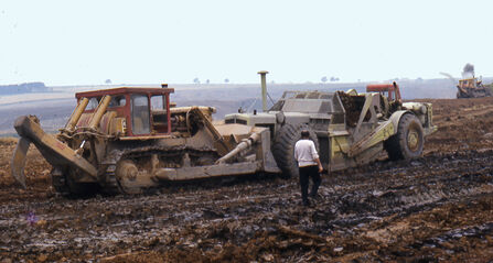
A heavily loaded Terex motor scraper gets a push from a bulldozer.
Credit - Brian and Elizabeth Nicholls Photography
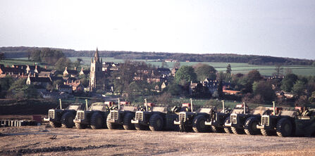
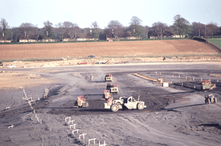
Seven of the 12 twin-engined Terex motor scrapers ready for work. View looking from the dam towards Empingham.
Credit - Brian and Elizabeth Nicholls Photography
Watering the clay prior to harrowing and further compacting.
Credit - Brian and Elizabeth Nicholls Photography
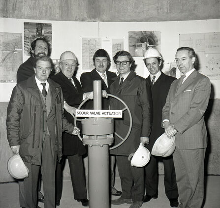
Filling of the reservoir officially commenced with the closing of the scour valve at a ceremony on 6th February 1975. In this picture are (left to right) Barry Gooding (Hydrologist), Harry Crowe (Reservoir Manager), Roland Field (Chief Scientist), Frank Knights (Reservoir Engineer), George Oglanby (Divisional Engineer), John Tindall (Finance Officer), and Peter Langford (Divisional Manager), all Anglian Water Authority employees.
Credit - Brian and Elizabeth Nicholls Photography
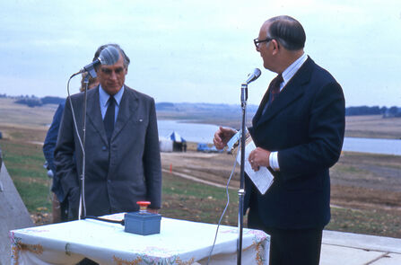
Dennis Howell (Minister for Drought, but nicknamed 'Minister for Rain') switching on the Wansford, Tinwell and Empingham pumps at what is now Howells Inlet near Normanton on 15th September 1975.
Credit - Brian and Elizabeth Nicholls Photography
Archaeology
As the soil of the valley was lifted, an opportunity for archaeological investigation presented itself. Thanks to a collaboration of locals, volunteers, historical societies and university departments, the history of the Gwash Valley was revealed.
Numerous finds were made including:
- An Anglo-Saxon burial site beneath where the Sykes Lane visitor centre stands today. 150 skeletons were found buried with grave goods, spears and shields. Around half the occupants of the graves had died under the age of 25!
- Two Romano-British farmsteads found either side of the Gwash, roughly where the ends of the dam stand today. Rings, pendants, game counters and loom weights were found in one, while the other possessed evidence of an underfloor heating system, painted walls, and a bathhouse. Most strikingly, a stone coffin was found at each site; in one of these were the remains of a man, and in the other those of a woman and child. The two graves faced each other across the river, feet pointed towards the water.
At Rutland County Museum, an Anglo-Saxon comb and bucket can be seen; examples of the finds uncovered from the Gwash Valley: Rutland County Museum – Rutland's Hidden Treasure
Nottinghamshire archaeologist Sam Gorin is a down-to-earth chap. But the blood really stirred in his veins when the driver of a giant excavator reported, ‘We’ve found eight Saxon warriors – and they’ve still got their helmets on.'
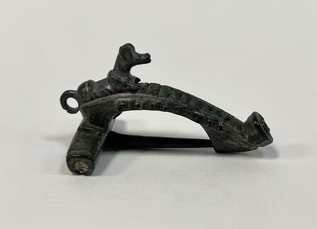
Fibula brooch of Romano-British period found during the excavations at Empingham in 1967.
Credit - RCM
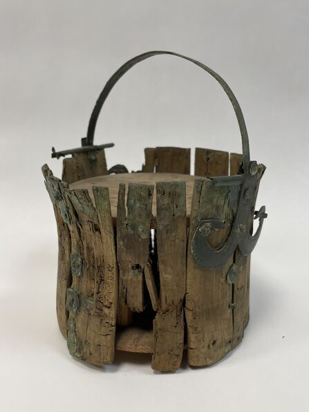
An Anglo-Saxon bucket
Credit - RCM
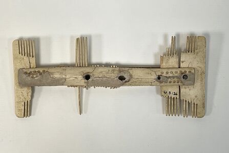
An Anglo-Saxon bone comb
Credit - RCM
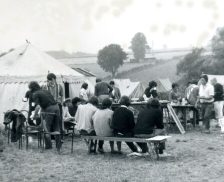
Students take a meal in their tented camp at Empingham
Credit - Shirley Palmer
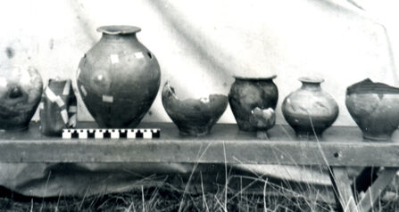
A row of reconstructed Romano-British pots
Credit - Shirley Palmer
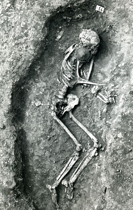
An Anglo-Saxon skeleton under excavation at Sykes Lane
Credit - Brian and Elizabeth Nicholls Photography
The Reserve
Rutland Water Nature Reserve was declared a reserve before it even existed, its potential being recognised early in the reservoir’s planning stages. In 1975, the Leicestershire and Rutland Trust for Nature Conservation (it was not until 1997 that the Trust became the Leicestershire and Rutland Wildlife Trust) signed a management agreement with Anglian Water Authority (later to become Anglian Water) to become its stewards.
The Egleton area, the shoreline by Lyndon Hill, and the Old Burley Fishponds were identified as the three main areas for the reserve. Lagoons were designed and constructed, islands were created, many thousands of trees were planted. Trails were prepared, hides were built, and volunteers contributed a huge amount of time and skill in the establishment of the reserve.
Even before the reservoir was filled it began to attract huge numbers of birds. Corn Buntings and Skylarks took over the wide-open spaces that had been cleared, Turtle Doves and Stonechats too. Waders began to appear as the first water started to accumulate, and vast numbers of ducks, like Gadwalls and Shovelers, arrived as the waters rose. It was not long after the reserve’s opening that counts of over 20,000 waterfowl were being recorded. Very soon, Rutland Water was recognised for both its national and international importance. In 1981 the reserve became a Site of Special Scientific Interest and in 1991, a Special Protection Area, and a Ramsar site.
The Lyndon Visitor Centre
The construction of the Lyndon Hill Visitor Centre began in 1984, and the building was opened in 1985 by Sir David Attenborough, the first of his many associations with Leicestershire and Rutland Wildlife Trust’s history. The current Anglian Water Birdwatching Centre at Egleton is unrecognisable nowadays from how it started off in life - as an 8ft by 12ft wooden hut.
The Birdfair
For over three decades, the British Birdwatching Fair – known fondly as the Birdfair – was the beating heart of the birding community. Held at Egleton at Rutland Water Nature Reserve, it wasn’t just an event; it was a celebration of nature, conservation, and camaraderie. The Birdfair earned its reputation as the ‘birdwatcher’s Glastonbury’, drawing thousands of enthusiasts from across the world.
Year after year, it raised millions for international conservation projects. It was where friendships were forged, collaborations began, and the shared love of wildlife united people from every corner. For those of us behind the scenes, there were unforgettable moments – like the many times I found myself pulling out cars, lorries and even a double decker bus from the Rutland mud! It was all part of the charm and the adventure.
Joe Davies, Head of Reserve Management
New lagoons
After a long planning period and nearly three years of site work, the Rutland Water Habitats Project was completed in early 2011. The creation of five new lagoons at the nature reserve provided an additional 120 hectares of habitat. Anglian Water undertook the project to expand and diversify the reserve’s ecological value, and to increase the reservoir’s water storage capacity, ensuring a more resilient water supply for the region. Thanks to the new lagoons and bund across Manton Bay and the north arm of the reservoir, the reserve gained a mosaic of wetland habitats – shallow waters, reedbeds and muddy margins. These areas support a wide range of species, from wading birds such as Avocets and wildfowl such as Wigeon, to a huge number of invertebrates and aquatic plants. The additional habitats have significantly boosted diversity and created safe breeding grounds and feeding areas for species that thrive in wetland environments. This approach exemplified how infrastructure development can align with conservation goals, turning a functional water management project into a thriving haven for nature.

Credit Tim Sexton - New lagoons at Rutland Water Nature Reserve
Wind in the Willows
Also in the spring of 2011, a Water Vole re-introduction project was launched at the reserve. Immortalised as Ratty in The Wind in the Willows, the Water Vole has suffered dramatic declines due to habitat loss and predation. Captive bred Voles were released at Rutland Water and Oakham Canal over several springs and summers to establish a new and healthy colony.
Believe me, my young friend, there is nothing – absolutely nothing – half so much worth doing as simply messing about in boats.
Ratty, The Wind in the Willows
The VTC
The Volunteer Training Centre (VTC) was completed in 2015 providing a dedicated space for the training, education and coordination of volunteers who are essential to the day-to-day running and conservation work at Rutland Water Nature Reserve. As the reserve grew in size and complexity, the need for a professional facility to support operations and volunteer development became clear. The VTC offers classrooms, workshops, meeting areas, accommodation and practical training spaces, enabling volunteers and trainee reserve officers to gain skills in habitat management, species monitoring, and visitor engagement. It also serves as a hub for local wildlife group involvement, fostering a sense of ownership and connection to the reserve.

Sir David Attenborough at the opening of the Volunteer Training Centre.
Credit - Eric Renno
WeBS
In 2025, another 50th anniversary was celebrated at the nature reserve – 50 years of the Wetland Bird Survey (the ‘WeBS’). The count monitors wintering (non-breeding) waterbird populations and assesses the ecological health of Rutland Water. Since September 1975 (one year before Rutland Water Nature Reserve was opened to the public), the WeBS at Rutland Water has recorded over 6 million birds, comprising 131 different species across the reservoir and nature reserve lagoons, thanks to 15,000 hours of volunteer effort.

Gadwall in flight.
Credit - Rod Baker
Rutland Ospreys
Ospreys were once a common sight in Britain, but in 1847, the last recorded breeding pair in England were shot, and the birds became extinct as a breeding species. However, when Rutland Water was created in 1976, Ospreys were seen flying over on their migration to nest sites in Scotland. After one was seen spending the summer at the reservoir, hope arose that maybe one day, they might return to Rutland. More information about the Rutland Osprey project can be found here: About the Rutland Ospreys | Leicestershire and Rutland Wildlife Trust

7R4, the 300th successfully fledged chick of the Rutland Ospreys project.
Credit - Stuart Wilson
Many photos and quotes, and much of the information in this article were obtained from ‘The Heritage of Rutland Water’, produced by the Rutland Local History & Record Society. This book is an invaluable source of information and history for Rutland Water. We are grateful for the help of its editors in the creation of this article. An online version of the book can be found here: https://www.rutlandhistory.org/hrw.htm
A huge thank you to all who helped compile this article and gave photographic permissions.